Saturday, January 31, 2009

Manilla Day1

Flying again. And Day1 turned out to be a nice flying day. The practice day was a bit flat, here we are riding up in the "Basher". Mount Borah has many Launches there are about 3 others you can't see. Yesterdays task went around Lake Keepit, (~62 mile triangle) which is a famous for sailplane flights. The area was a covergence zone between the coastal NE, and continetal SW airmasses yesterday.
Here is the town of Manilla - where I landed next to the cabin where I am staying. Godfrey's LZ has some really nice eagle carvings.

Tuesday, January 27, 2009

Australia Day at Stanwell

It was Australia Day on Monday, flags were flying and higher at Stanwell park. Looking north, Blay in the foreground. Davis and a few of us test flew Malibu's. Very Docile glider. A few Sea Eagles were flying around with us. They were not at all agressive, a pleasure to fly with unlike Wedge Tailed Eagles. Blay over Stanwell Park town contemplating how low his sprogs really are. Huge thanks to Curt and Louis for hosting a delicious BBQ.

Friday, January 23, 2009

Bogong closing ceremony

This year is the last that Carol and Heather are organising and running the Bogong cup. They did a fantastic job and everyone had a blast. Here are the overall winners Curt, Jonny, Steve B, Blay, Corinna, Lucas, Scott, Artur & Phil. In the female catagory Corinna, Julia and Hadewych. Heather and Carol are also pilots. Clare, our team captin picked up the best driver award, (she really was fantastic). Rodger picked up the TIWTIWGD award, wind tech'ing on a day when no-one else flew.

Wednesday, January 21, 2009

Bogong : day 8, task 3

It was quite bumpy today. The task was an "M" shape with legs into a 20-30km/hr. We launched from a NNE facing site called Towanga gap. Being cloase to the back I was lucky to get on the alternate list, and launched 3rd. Otherwize I would have been back in the trees and on chase again. The climbs were good despite the wind and roudy air. I took the first start clock. I battled along the course catching pilots that had passed me then being passed again. It was weird spending an hour to go 10kms and almost sinking out at the turnpoint, then 40mins to scratch back up and go the 22kms to goal. Stranger still was there were only two gliders there. It turns out they hadn't flown the task! I was first in goal, Blay was right under and behind me, he took the second start gate. Turns out I came second for the day!! I was pretty stoked since I have been making an effort to fly more efficiently recently, and up until now it hasn't been working so well. I also got to fly with Corrina and Lucas quite a bit which was fun.

Task 3 Results

Mountain biking in the Aussy Alps

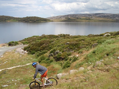
No flying yesterday, and as you can see below for very valid reasons. The hail was about marble sized and fell for 15 mins, that was preceeded by some pretty heavy rain. Our plans of mountain biking around Falls Creek were starting to look a bit damp. Below is ruined castle which is an exposed Basalt inclusion. Hexagonal or pentagon colomned were formed, 20 million years ago or so. The highlands up there remind me of Scotland. Though the naming isn't nearly so romantic, this body of water has the rather uninspiring name of rocky point storage. It is quite pretty though. Lots of heather and late spring flowers. We rode down a trail next to Langford Aquaduct. Across a creek or two. And on up to a point where we could see Shannonvale, by which time we were all quite tired enough. Its been a while since I rode a hardtail offroad. Fun day !

Monday, January 19, 2009

Bogong : day 5, task2

Bogong Results

Task 2, we flew from Mt Buffalo which is a spectacular launch in itself. A little like Yosemite but you can soar. Teammate Neil off the ramp.
Looking down at the visitors center, and Launch is down and to the left. The task had us start 25km from the turnpoint Mt Feathertop (second highest peak in the state of Victoria). Then back north to Mt. Porepunkah, on to Dedarang and back to Mt Beauty airstrip for 124km. Looking back over Mt Feathertop. I bombed out at the third turpoint having chosen the wrong line.

Saturday, January 17, 2009

Bogong Day 4 Task 1

A promising start to the day today. We went over to a site called Mystic and flew from there. A ~120km task was set in a backwards "h" shape, ending at Mt Beauty airstrip.
Mount Buffalo can be seen to the left and northwest.
It is a national park and quite spectacular. It even has some hang gliding launches next to the visitors centor building (you can see in the centre if you look closely). Clicking on the picture expands it.
I took the first start at 2pm and did really well upto the 3rd and last turnpoint, then I got low and floundered a bit. I made goal, but scored zero for the day I believe. I strayed into airspace. With the resolution of my GPS it looked like I would have been outside, but as I went on course I didn't recheck and the hassel was problematic. I could not really see the airspace track on the screen because it was blocked by all the waypoints. To compound the problem I had auto-zoom on which retakes control of your screen after a few seconds. Since landing I have learned how to hide all the waypoints from the map view, disable the auto-zoom feature, and make the airspace tracklog black and my tracklog white so I can see them both... Lesson learned. I suppose it is not until I try to use these tools for something new, that I realize that there are inadequacies, deficiencies and better ways of doing things. It is neat to have the Airspace as a tracklog that you can see!

Wednesday, January 14, 2009

Bogong, hot and cold.

No flying yesterday and it was 41'C (106'F) and the forecast was for strong wind from an unfavourable direction. No task today, the lift was scant and light virga plentyful. So we took pictures instead. Many of us flew anyway, this is my team mate Neil on his Aeros combat with Mt Bogong in the shade behind him. So, no results yet...
the website is http://www.xcflight.com/index.html
and of course http://www.davisstraub.com/OZ/

Tuesday, January 13, 2009

Bogong Classic

Two days later, and the next competition is about to start. Today I took the practice day and flew off Mt Emu. Here is Launch. A few of us climbed straight up to Cloudbase. Here is the town Mount Beauty, where we are based for a week or so. Warren was flying with a mounted camera and we tried to get some pictures over Mount Bogong. Here is the Kiewa Valley. The flying area looks and feels similar to Woodrat. The Kiewa River is a good spot to cool down after a hot brake down. This is the team I am flying with this week, Warren, Niel and Roger.

Sunday, January 11, 2009

Forbes - nail biting finish.

The Day started look fabulous, but as soon as the inversion broke, and the race started, the sky was also competing. The Cu-Nims won the race to goal and the day was stopped at 2:48pm. Jonny beat Blay for the day by 41 points, but needed 3 more! Blay wins the comp!

Saturday, January 10, 2009

Not luken' reel guud mate.

The forecast was for storms at the begging of the start gate yesterday. They were right on cue. Here is the team I have been flying with. Len has been driving and giving me some great direction, he is one of the top pilots in Australia, taking a short break from flying. I am very lucky to have gotten into his team, Guy has been kicking my ass daily. Geoff has been flying well too. Laura is keeping us in line. Between them I have had a few outback tours of the local flora and fauna. The outback may start a bit farther west... Everyone has there own interpretation of where the "black stump" is. Final Day today and Blay has only 40 points on Jonny, so that should be a pretty good race. I hope to make goal and maybe get some arrival points :) The winds seem light, it would be nice to do a triangle.

Thursday, January 8, 2009

Here are the results so far. Two more days to go. Already flown 24:43 hrs and 558.2miles this week!
http://www.moyes.com.au/Forbes2009/Results/Results.aspx

Yesterday the task was 288km to the north. There was some interesting air on the way, a heavy inversion at 4700ft which I punched through at Gilgandra, into what felt like wave or wind sheer. Smooth 200ft/min up everywhere. Lower down the thermals were torn apart by the wind. I sank out 25km from goal, but for a personal best of 151.5 miles. After breaking down I noticed two wild Emu wondering around. I am told this is a TSR (Travelling Stock Route), which I presume to mean a route for migratory animals.

Wednesday, January 7, 2009

Thoughts on a non-flying day

In the last flight (task4) I was on glide to goal from 25km out at 12:1 (finally got one right). I was flying at about 65mph and for whatever reason sneezed. A split second later I realized I had to make the conscious decision to close my mouth (it was still inflated open by the airspeed). The humour of this little situation tickled me and I found myself sniggering to myself as I blazed into goal at 200 feet. Its a little random but I thought I would share...

We did not fly yesterday on account of stormy weather. So I spent a fair bit of the day thinking about flying instead. I have been making goal more consistently but I am still getting my arse kicked. Jonny and Len (A great Aussy pilot) have given me a few clues, saying I am turning to much. This means I am not thermaling efficiently, and stopping in weaker lift when there are stronger climbs to be had. One of the things I have noticed is that the thermals seem to behave differently out here (or is it that I have only just noticed a dimension to thermals that I haven't before?). Either way the thermals seem much wider sometimes even a few km wide, with many cores. Better pilots slide, turn and yaw through the thermal, until they get to the main core of the thermal. The core is by no means in the centre, and will often move with altitude and time. So how do they do that? Is it all by feel and practice?

Thermals are invisible, but the evidence is not. So we form pictures in our mind of what the thermal is like based on the evaluation of our senses, feel, sight and even smell and sound. This model, takes into account assumptions and constants sometimes that are not correct. The more sophisticated the model, the fewer assumptions and constants there are. So I have been re-evaluating : what assumptions I am making, and what I maybe thought constant, often subconsciously. This is not as easy as it sounds. Maybe an analogy might be driving a car. How often do we consciously consider the friction coefficient of the road surface and our tyres, taking into account the surface (lose gravel, oil, water, holes, camber) suspension travel, weight of the car, centripetal forces, suspension damping effects). There is more to travelling safely and efficiently than the speed limit. Hopefully you get the idea, these evaluations are not always conscious, it is the same with flying. The more sophisticated the model the better pilot you may be, providing prioritization of the most important factors can be managed.

I've also been thinking about the points system now I am making goal a little more regularly. I will leave that for another blog. Day6 of 9 today. Tomorrow is Steve's memorial service, no flying tomorrow. More soon.

Tuesday, January 6, 2009

Back to Gulgong

Another big day yesterday (task 4). 121 miles. There were some gnarly thermals ripping through launch yesterday. Its the first time I've seen a glider forced down to the ground from 100 feet. Luckily the pilot was only concussed. The Oz report has more detail.

Here are some of the tracks from the last two comps, starting to cover quite a bit of south eastern Australia. Here is a tip I picked up in Gulgong last year. Write down the task on a roll of masking tape. Then stick it to the base tube. This came in handy yesterday when I miss programmed my GPS to Gulgarg, instead of Gulgong. I would have noticed anyway with the goal being 200 miles away instead of 80, but its a good tip anyway.

Monday, January 5, 2009

Forbes Day3

Today had a great forecast. The wind came up so a downwind dogleg task was set. 163km if my memory serves me correctly. There was a cloud line downwind, base at 12K +
At the first turnpoint things were going great, I had caught about 15 pilots, having taking a better line and finding a fast climb.

After the turnpoint I hit major sink and got stuck low in weak lift over a valley 40km from goal drifting off course. Eventually I had enough altitude to find a better climb, with a cloudstreet to goal. But by then I didn't need the 3000' I got just flying straight ! I got the goal late and high. Maybe I will figure this out tomorrow... Thats goal waaay down there. The white is the finish line.