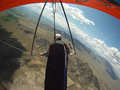
With two flights to Salmon, one to May, one to the cement plant on route 3 only good enough for 6th, you can tell it was an exceptional year.
Even with flights that good I find myself asking how could I have flown better ? What, where and when would have made a difference ?
Probably the first day, made the biggest difference. While flying along route 1, there was a wall of light virga with a gap or window of opportunity to fly through. As a team, and after good discussion we flew threw it thinking conditions would worsen through the day. There was an unfreindly gust front some 8oooft below us after gliding through the window. We crossed into the valley behind where we would be safe from that gust front. The turbulence crossing the mountain range was enough for my carabiner to be facing the other way on landing. We got flushed in that next valley, and were all happy to be safely on the ground. An hour later, those more patient flew 10,000ft over us And glided 40miles passed into Salmon.
The third day, route 3 was called, but I got a very late start, maybe 1.5 hour after those that did well left. I also took an interesting route (around Arco a 15 mile detour). This was a challenging 10 mile punt into a 20+ mph headwind. But it payed off as I ended up up wind of courseline under a nice cloudstreet. As I was gliding I tried to skip a cloud that didn't work (with the little attention I spared it) and the sink was too much to reach the next street. That mistake put me on the ground. At the time I was OK with that as the sky ahead looked not so great,
but of course 20mins later it looked fabulous...
The last day, had amazing conditions. If I hadn't neglected my vario, so that it was actually working, I am sure I would have made much better of the day, and got to see more new terrain (for me).
During the meet, there were definately some key moments where I knew I was at a strategic decision point, and where I was unsure which was the better of two options. In the end (especially in open distance) patience appears on average the better strategy.
The final scores are published
here : www.flykingmountain.com/contestresults.html#results2011
Dave Aldrich, Jared Abrams, Rod and more came out to collect ariel footage for the Movie "Dreaming Awake" (link). I Can't wait to see what they got :)Trey also made this very entertaining video. King Mountain
The event has been over a couple of weeks now but the stunning scenery, wild weather, the camaraderie all live on.
Thursday, July 28, 2011
Monday, July 18, 2011
Going into the last day at King Mtn
The town fed us breakfast Saturday morning, the final day of the meet. As we sat there eating many of us knew it could be a game changing day. Some of us had a spare but low score day, and for others the day would count in full. Bill had a sore shoulder and was undecided as to whether or not to fly.The forecast was for a strong crosswind. Generally this means winds out of the canyon from the left. Surprizingly the air came straight in almost.The air was very bouyant everywhere. Which was lucky for me as I had neglected my vario, and it was not working.I figured out how to use my GPS as an alitimeter and vario and carried on, I don't know what the the time intervals are, certainly not the same as the vario thats for sure.Mostly I flew straight in the bouyant air. Working the surges, the thermals were not subtle, so after a bang or too and a couple of circles I could check the climb averager to see what my climb was. The Terrain was stunning with very little haze in the air. Before crossing the Lost River range I worked up some altitude. And crossed through double springs pass. The wind was southerly and there was a cloud street right on course. Why not ? My Go Pro camera filled soon after and missed the amazing views on the way to Salmon. This time I made the designated fair grounds LZ for 104 miles or so. Not bad for flying without a vario. Here are the trophies to be awarded. Scores will be published soon here: www.flykingmountain.com
Saturday, July 16, 2011
day5 of 6 -King 2011
Here are the scores as of yesterday morning. King is scored best four flights (of six). After yesterday most of us at the top ) except Bill have 4 flights. So today will be a score changing day.Yesterday over developed quickly, sounds like it did in every direction. Here is the route (3) ahead... And behind. I could not find a way through and decided to land, teammate Wayne did find a way through an hour before and will likely win the day.It a fun place to be. I am thinking about my compadres getting ready for the world championships in Italy. I wish I could have made that work. But the US does have a strong team this year. I'll be cheering from afar :)
Friday, July 15, 2011
King -Day4 of 6
Its day 5 today, and we've had 3 reasonable days. We've had strong Southerly winds all week. Strong winds and mountains are not my favourite mixture... However the flying has been great despite the wind strength. Task2 (route 1 was called) had many pilots flying 60miles and I had my first trip to Salmon (103miles). We have a great turn out from our local Californian club. It even looks like we are missing a couple of folks here. Ryan, Walter & Bob, who are also here.Route 1 is so pretty up near Mt Borah that I always wish I had taken more pictures from different angles.The crossing of the range was way smoother on the Second flight.After gliding 55miles I came out of the Salmon River canyon at about 7k not a bump, I ended up landing in a 20mph NE wind, after flying most of the flight in a 23mph SW ! I am guessing the ground was wet the last 45miles since there was no real thermal activity.We went into yesterday with the following scores. Look who in the lead !! Lisa Versella !! She is flying exceptionally well on her new glider.After mis-judging the weather I ended up getting a very late start and missed the real window of opportunity. The winds had gotten pretty mixed up in the valley with a 15mph WNW cold storm outflow under 6800ft and 23mph South above that and West at 32mph above 12k. The layer at 7k was particularly spooky, and gave me quite an exhilarating glide (or lack of!) right after launching.I did not want to land in that rubbish air, so I persisted flying south to Arco, before turning on course.
It took over an hour to fly those 5 miles ! Thats launch in the right of the picture.From there it was easy miles, until I flew into a blue hole.In hind sight I recognise my mistake, with the wind @ 30mph I could easyly drifted with the cloud that was working over this area...However the weather was pretty wild behind and catching, and infront didn't look that great either. So I was happy to be on the ground
Monday, July 11, 2011
Lost River Valley - now found
Yup it is July and time for the King Mountain Hang Gliding meet 2011.I've not made this meet in 3 years. The mountain ranges here are amzingly beautiful.This year there has been more snow and later in the season too, so I was excited to get some pictures of the flying here.My go-pro battery was discharged when I turned it on, so I had to make do with point and shoot instead for todays flying.
The weather was a challenge to read today. We enjoy challenges. We didn't get it totally right, but we do get to fly again tomorrow.We did fing a rather nice beer room in Challis.We also found Dr Paul, in his quite scenic Landing Zone.
Saturday, July 9, 2011
Flying in the midnight sun
Well that was the goal at least.We set up this old but in great condition glider. It was single surface, had curved wingtips (same tubing as the leading edge, triple deflexors and straight spruce battens, no luff lines. I am guessing a late 70's glider.I had a couple of students that day, the weather wasn't great, but we made the best of it. We found a spot near Eagle summit where the winds were laminar-ish and the ground was not too steep. It was a little windy.The sun bottomed out at 1:45am we reckon and then started climbing back into the sky.This is about as low in the sky as the sun got. We were about 40 south of the Arctic circle and at about 4000ft MSL.Later we went to soak in the slightly dilapidated hot springs.
The water was nice though, and the pool huge !
The northern most fly-in.
The water was nice though, and the pool huge !
The northern most fly-in.
Thursday, July 7, 2011
Time Zones and Temperatures
I am easily confused in time zones checking weather forecasts.
For Example in the NWS Winds Aloft forecast data is in Zulu time, also know as Universal Time, UTC, or GMT (Greenwich Mean Time).
The forecast is based on data from Zulu time, for sometime in the future also Zulu time. Moving from timezone to timezone and getting thoroughly confused I decided I needed to help myself out. I've also been learning some JavaScript. That's what the numbers are in aide of top right of blog.
And what do the NWS winds aloft forecast numbers mean anyway ?
SFO 2507 2508+21 2412+15 2309+08 2607-08
:-
at 3000ft MSL wind is from 250 degrees (WSW)
at 6000ft MSL wind is from 250 degrees (WSW) 21'Celcius
at 9000ft MSL wind is from 240 degrees (SW) 15'C
at 12,000ft MSL wind is from 230 degrees (SW) 8'C
at 18,000ft MSL wind is from 260 degrees (W) -8'C
DALR (Dry Adiabatic Lapse Rate) is 9.8°C /km
or ~1°C per 100m
or 5.38°F /1,000ft
If it is drier the Lapse Rate is less (maybe 4°F /1,000ft)
If it is wetter the Lapse Rate is also less (maybe 3°F /1,000ft)
So as soaring pilots we are always looking for those "popcorn skys"
Indicators of the desired humidity and lapse rate as well as to the location of lift.
Of course clouds tell a much more detailed story, but that's another story for another day.
Wednesday, July 6, 2011
The biggest National Park in the U.S. is ?
The 13.2-million-acre Wrangell-St. Elias National Park and Preserve. That was the next adventure on the Alaska trip. This time quite a bit more in civilization (actually more than I anticipated). A solid days drive from Fairbanks of which the last 2.5hrs is dirt. Prepared for a few days "off grid", I was surprized to see a guy talking on his cell phone in the camp! We were staying west side of the Kennicot ice melt river in McCarthy.The town of McCarthy is one of the oldest in Alaska, it has 42 residents, a few of which stay there all year. It grew as a supply town for the people that worked in the Kennicot copper mines. Most of the buildings are in as good condition as in their hay day (1920's)
These days it is ground central for tourism, the place has no less than 3 airstrips! (one for every 12 residents) We stopped in the saloon to find a great atmosphere. It was pre-tourist season, everyone was very friendly, great vibe in that town.
Up the road is the town of Kennecott, where the copper ore was milled and sorted for transport is being rennovated. It's an interesting mixture of National park and private property, and it works very well. It had a European feel to it that way with a bit of wild west thrown in, a buzz of different commercial enterprizes.
Bruce and I walked up to the Kennicot glacier snout. Without crampons we didn't venture very far, and in this case they were necessary.
Instead we walked up to the Bonanza mine, one of five big copper mines.
There are many glaciers in the area too. Just 10 miles north the Nabesa plateau stands around 10,000ft. Needless to say it accumulates lots of snow. Interestingly is a considerable amount of gravel on top of most of the glaciers.Three glaciers come together to form the Root glacier.
The town of Kennicot is at 2200ft msl, the Bonanza mine is at 6000ft, a pretty nice walk :)
A Bald Eagle gave us a nice fly-by on the way up.
We walked up over the ridge for the view. Spectacular in all directions.The was considerable mining below the surface, perhaps why it looks fairly natural up there, or maybe the erosion is so fast here from snow and freeze thaw hides the blasting.
In the afternoon the skys cleared and it was possible to see Mt Blackburn standing at 16,010ft, impressive as viewed from just 2000 above sea level, almost 3 miles straight up.
Instead we walked up to the Bonanza mine, one of five big copper mines.
There are many glaciers in the area too. Just 10 miles north the Nabesa plateau stands around 10,000ft. Needless to say it accumulates lots of snow. Interestingly is a considerable amount of gravel on top of most of the glaciers.Three glaciers come together to form the Root glacier.
The town of Kennicot is at 2200ft msl, the Bonanza mine is at 6000ft, a pretty nice walk :)
A Bald Eagle gave us a nice fly-by on the way up.
At the mine site, immediately you notice the rock colours, green, blue and black, mostly copper ores, with some limestone here and there.
The Structures themselves are in great shape considering their age, environment and that they have mostly been left to the elements for the best part of 70 years. Maybe the fact that it gets down to -60'F here frequently in the winter, removing all mosture from the air, prevents the timbers from decomposing.We walked up over the ridge for the view. Spectacular in all directions.The was considerable mining below the surface, perhaps why it looks fairly natural up there, or maybe the erosion is so fast here from snow and freeze thaw hides the blasting.
In the afternoon the skys cleared and it was possible to see Mt Blackburn standing at 16,010ft, impressive as viewed from just 2000 above sea level, almost 3 miles straight up.
While there Bruce and I also took in the 2.5 hour mill tour, the inner workings from the 1903 design were fascinating. And to think of the logistics of bringing in the building supplies and machinery by horse wagon and dog sled from the Valdez Fjords is mind boggling, especially as it was a year round operation back then!
Subscribe to:
Posts (Atom)